Impacts of El Niño on the Port Industry
Researchers from NOAA, the American National Oceanic and Atmospheric Agency, warn that the El Niño that begins in 2023 has more than a 95% chance of continuing to develop, with a high probability of being particularly strong (67%). If the predictions are confirmed, the impacts could be significant.
A strong El Niño is often associated with extreme weather events. A recent study on the persistent effect of El Niño on global economic growth, published in the journal Science, estimates that El Niño 2023 could cost up to US$3.4 trillion (about R$16.6 trillion) for the global economy in the next five years.
Years in which El Niño occurs tend to be warmer than normal. Therefore, we are talking about a significant warming of the atmosphere that will add to the current global warming crisis.
In addition to temperature, this phenomenon alters other climate patterns such as ocean circulation, wind, rain and cyclones, with direct and indirect impacts on ports and maritime and river transport. In this article, we will talk about the main impacts of El Niño on the port sector.
1. What is the El Niño phenomenon.
2. How El Nino impacts the global climate.
3. How El Niño impacts the port sector.
4. What to expect in the coming months.
What is the El Niño phenomenon and how does it work?
We hear a lot about the El Niño phenomenon and its opposite, La Niña. Both are naturally occurring phenomena that alter weather patterns around the world.
El Niño involves the abnormal and persistent warming of surface waters in the Equatorial Pacific Ocean. During the phenomenon, these waters are at least 0.5 °C above average for a period of at least six months.

For El Niño to develop, the changes we see in ocean surface temperatures must be accompanied by changes in atmospheric patterns above the tropical Pacific. In this case, the trade winds lose intensity and drier conditions and higher atmospheric pressure are observed in the western Pacific and Indonesia.
In this way, atmospheric changes feed back oceanic changes and vice versa. This effect is called ocean-atmosphere coupling and determines how El Niño will develop and how much it will impact the climate in various regions of the world.
La Niña is the opposite phenomenon, in which ocean temperatures are below average and trade winds intensify.
El Niño and La Niña episodes typically last 9 to 12 months. Both tend to develop between March and June, reach peak intensity between November and February and then weaken between March and June. The longest El Niño in modern record lasted 18 months, while the longest La Niña lasted 33 months.
Now in September, when I write this article, we are right in the middle of the development of El Niño, which will probably reach its peak between the end of 2023 and the beginning of 2024. But what impacts can we expect associated with this phenomenon?
Impacts of El Niño around the Globe
El Niño changes the climate pattern in several regions of the globe. The direct effects often include increased rainfall along the west coast of the Americas — bathed by the Pacific Ocean — and decreased rainfall around Indonesia and Australia. Causing floods on one side and droughts and fires on the other.
Although the strongest impacts are in areas closest to the equatorial Pacific, El Niño can alter seasonal temperature and precipitation patterns around the world. In any given decade, the warmest years are generally El Niño and the coldest are generally La Niña.

Like every climate phenomenon, El Niño is not always the same. In addition to the increase in temperature at a global level, some of the most recurring effects are:
- Droughts in Indonesia and southeast Asia, northeast South America and southeast Africa, and
- Excessive rainfall and storms in southeastern South America, southern United States and coastal Gulf of Mexico, around the Horn of Africa and eastern Asia.
Other effects of El Niño also include drier conditions in parts of Central America and the Caribbean, India, northern and eastern Australia, Canada, and the northern United States.
The development of El Niño usually leads to a more active hurricane season in the eastern and central Pacific. Meanwhile, hurricane activity in the Atlantic Ocean decreases.
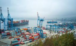
Impacts of El Niño on the port sector
In the port sector, El Niño can cause several direct and indirect impacts due to the changes in climatic and oceanic conditions that it triggers. Some of the main impacts include:
1. Impact on logistics operations: Extreme weather events, associated with El Niño, can cause disruptions and delays in port operations that can ripple through supply chains, resulting in widespread economic losses.
2. Flooding and infrastructure damage: The combination of strong winds, heavy rain and rising sea levels can increase the risk of flooding and damage to port infrastructure, including equipment, storage facilities and loading and unloading areas.
3. Variation in cargo demand: Impacts on agriculture, increased Pacific hurricanes and lower water volumes in river channels can lead to changes in cargo demand, route preferences, delays, reduced cargo capacity and increased cost of transportation.
4. Changes in vessel maneuverability: Changes in wind patterns and ocean currents can result in changes in the hydrodynamics of ports, affecting vessel movement, anchoring and vessel maneuverability.
5. More frequent dredging: Changes in current and wind patterns can contribute to silting and sedimentation of port navigation channels. This may require more frequent dredging actions to keep the channels in suitable condition for the passage of ships.
To minimize the impacts of El Niño, port operators often implement climate risk management measures, such as advanced climate monitoring, contingency plans for extreme events, preventive infrastructure maintenance and coordination with other actors in the logistics chain.
What to expect in the coming months
Climatologists recently announced that the climate phenomenon El Niño has already formed and will strengthen until the end of the year and during the first months of 2024. The last time El Niño formed was between 2015 and 2016 — and its effects were felt all around the world.
As climate change advances, the development of a strong El Niño will likely lead to a new peak in global warming and increase the chance of breaking temperature records.
Historically, in El Niño years, climate events have not necessarily been more disastrous than in other years, but they are more predictable. In the event of El Niño, the impacts may be related to a specific and well-studied climate phenomenon, facilitating mitigation and adaptation actions.